The 14 best places to visit in Iceland

As a sliding sports enthusiast and Nordic country lover, I had such an amazing experience during my first trip to Iceland that I went back several times. You can’t even imagine how many incredible locations and upcoming experiences this island has to offer. Here’s my selection of the best places to discover, from the most popular attractions to the most secret jewels. Grasp plainly the force of the natural elements during an excursion to the geothermal area of Myvatn or at the powerful waterfalls of Dettifoss: there are not many places in the world where you can see for yourself how lively and powerful is our planet Earth. Photography lovers and bird watchers will be delighted to discover the colourful volcanic landscapes of Landmannalaugar region and the Puffin colonies of the Vestmann Islands. The capital city Reykjavik will surprise you with the richness of its cuisine and musical scene, and how pleasant it is to stroll downtown and its colourful and richly decorated alleys. Relaxation will also be on the page thanks to the many natural hot springs in the country. Finally, some out-of-the-box locations will please the most adventurous souls! For instance the Askja caldera or the small ghost village of Djupavik. Visiting Iceland during the Arctic winter is also a very enjoyable experience and will allow you to observe the enchanting Northern lights... a seducing option for anyone!
Tourist attractions
Our selection of must-see places

Dettifoss Waterfalls
Iceland is often described as “the land of Ice and Fire”. But it is also, and without any doubt, the kingdom of waterfalls! They are all scattered across the country, each of them having their own specificities and character. Among them is the Dettifoss waterfall (Foss meaning “waterfall” in Icelandic), it’s one of the island’s most precious jewel. 45 metres high and 100 metres wide, the volume of water that is propelled at every second from the Jökulsa River is unique in Europe. Its spray can be seen from more than a mile away and it is frequent to observe double rainbows forming over the waterfall. A powerful display of Nature’s splendour. It is situated in the Jökulsargljufur National Park, an unspoilt area in the northeast of the island which is home to a splendid 20 miles long canyon in a moonscape made of volcanic rocks. No wonder it was used as a setting for the opening scene of Prometheus, Ridley Scott's science fiction film. When you get closer to the cascade, the show is even more impressive knowing there is no safety barrier. Guaranteed thrills!
Nature | Waterfall | Volcano | Hiking | Viewpoint
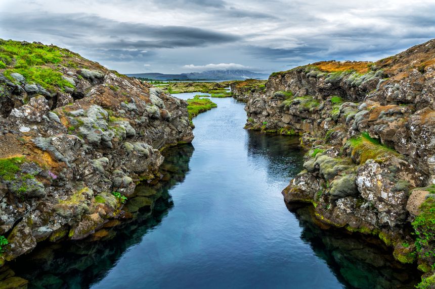
Thingvellir National Park
This national park is situated 30 miles East of Reykjavik. Listed as UNESCO World Heritage in 2004, the enchanting beauty is only matched by the historical and symbolic character of this site, which is so important to Iceland. Indeed, the Viking settlers founded on these lands in 930 the first Parliament in the world, known as the Alping. It was used to meet every year until the 18th century on the Lögberg, or Rock of Law, where a man solemnly recited the law before the assembly. Unfortunately, there is not much left of this historic building today, apart from a church and the ruins of old stone shelters. Located precisely on a border of tectonic plates, the site is the location of a constant struggle between the European and North American plates, which are moving several millimetres apart from each other every year... As a result, the Thingvellir plain is marked by a series of impressive cracks in the rock, including the large Almanagja fault. The moss-covered solidified lava fields are breathtaking, and it is even more interesting to visit the park in Autumn when the birch forests are adorned with a multitude of colours, ranging from golden yellow to blood red.
UNESCO World Heritage | Nature | Volcano | Hiking | Diving
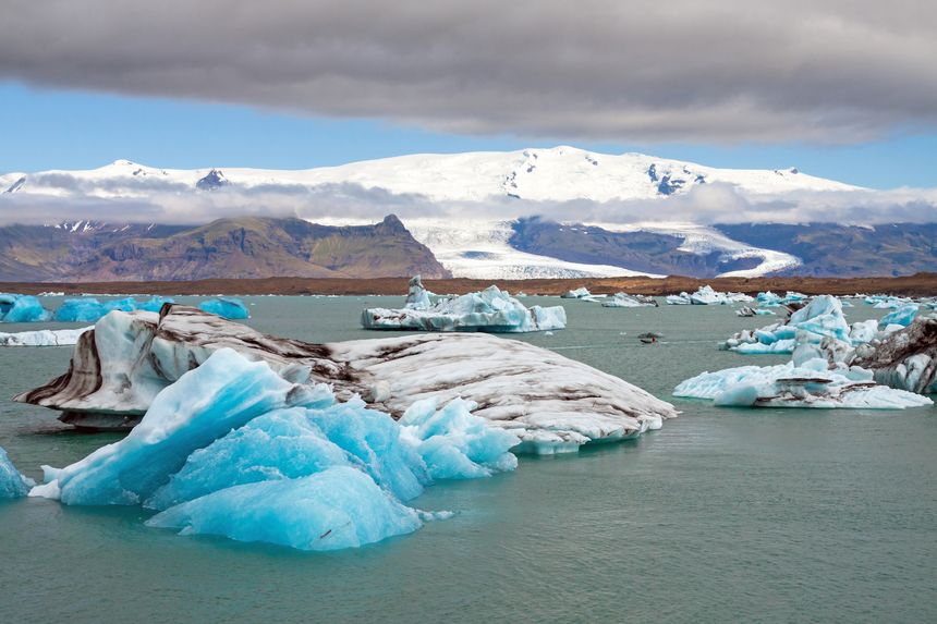
Jökulsarlon
Once you have taken Route 1 from the west and passed through vast expanses of black rocks on the south coast of the island, the gigantic Jökulsarlon and its stunning display of ice stretch before your eyes. Lying south of the Vatnajökull glacier, which is the larger ice cap in Iceland (roughly the size of Corsica!) this glacial lake appeared in the mid-1930s during a period of rising temperatures, recessing the glacier tongue and resulting in a process of "calving" or iceberg drop. 30 metres high ice blocks regularly fall from the ice tongue of Breidamerkurjökull, their multicoloured shades go from turquoise to dark blue, including yellow from volcanic sulphide, black from the ash of volcanoes, and several shades of white. They drift slowly on this lake and end up reaching the sea, standing on a black sandy beach and thus creating contrasts of astonishing beauty. A must for photography lovers!
Natural wonders | Mountain | Sea
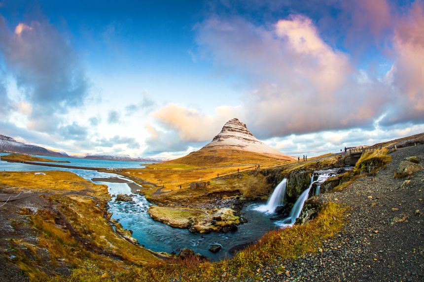
Snaefellsnes Peninsula
Located north of Reykjavik, the Snaefellsnes Peninsula is home to a variety of interesting landscapes and has been known as "Miniature Iceland": stunning fjords, volcanic peaks, impressive cliffs and huge sandy beaches are all worth a visit in this wild 62-miles long unspoilt landscape. The region is overlooked by the imposing silhouette of the Snaefellsjökull, a volcano topped by a perfect ice cone rising to nearly 1500 metres (4900 ft) Short literary anecdote: Jules Verne's adventure novel Journey to the Center of the Earth features two German geologists guided by the 16th century Icelandic text descending to the centre of the Earth via one of the mountain's craters. In 2001, this region of great beauty and geological interest became Iceland's latest national park. Most of the inhabitants of the peninsula are living on the mountainous and tormented northern coast, precisely in Stykkisholmur, a nice small fishing port built around a natural port which is protected by a unique basalt island. Its colourful wooden buildings are full of charming cafés where you can take a break if the weather suddenly turns to rain...
Nature | Volcano | Sea | Beaches | Nice village
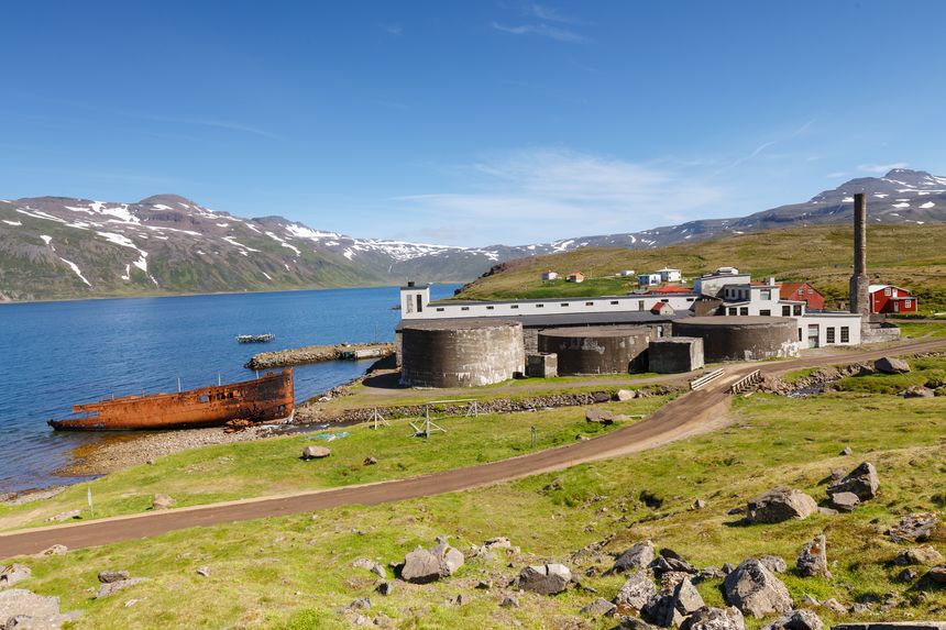
Djupavik
As you leave the small village of Holmavik by the gateway to the western fjords and follow the track to Djupavik, you really feel like you are heading for the end of the world.... There are not many places in Iceland with such an enchanting and powerful atmosphere. Djupavik was once a thriving centre for herring processing until the village was abandoned and the factory closed in 1950. The village is located on the Strandir coast at the bottom of an impressive cliff and a waterfall in Reykjafjordur. The former buildings in which the women used to work were turned into a hotel, the only permanent residence in the village. In the 1980s, Eva and Asbjorn, a couple of Icelanders from Reykjavik, fell in love with this place and decided to transform it and to raise their three children in this very particular setting. During the summer season, the area offers very nice walking and kayaking opportunities. In front of the hotel, a ghost-like atmosphere is added by the presence of a boat wreck, especially with the morning fog taking over the Fjord. Some of the abandoned factory buildings were used to create a surrealist setting for a concert of the famous Icelandic band Sigur Ros.
Nature | Sports | Unusual place | History
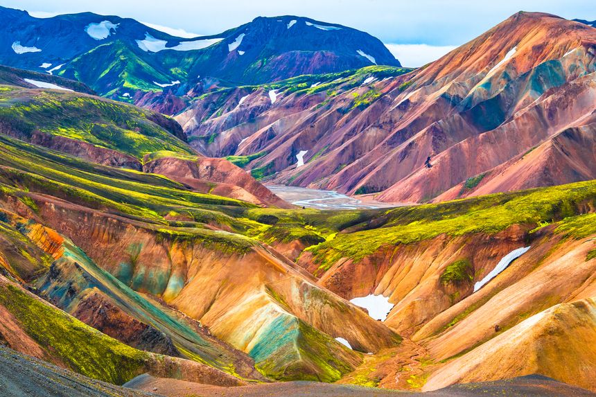
Landmannalaugar
Landmannalaugar, which literally means “people’s pool”, is located in the southern highlands of the island, close to the well-known Hekla volcano, and constitutes one of Iceland's major geological sites. Accessible only in the summer and with a 4x4, it is a real work of art from Nature! The trail leads to a spectacular setting where volcanic activity has given life to reddish craters and ash fields alongside deep blue lakes. Its mountains are formed by rhyolite, mineral-rich lava that has cooled very slowly, creating this palette of colours. A unique spectacle. Brennisteinsalda is undoubtedly the most colourful mountain in Iceland, with its rainbow coloured slopes. A path leads to its summit and allows you to admire this absolutely unique mineral landscape! The Laugahraun lava flow can also be explored on foot, the occasion for a most original hike in the heart of the dark, solidified obsidian residues. The end of a good day's hiking can also be the opportunity to swim in a geothermal river whose temperature is around 104°F, a real treat after the efforts you made!
Nature | Volcano | Mountain | Hiking | Relaxation
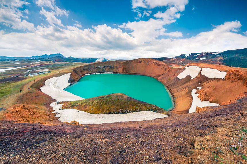
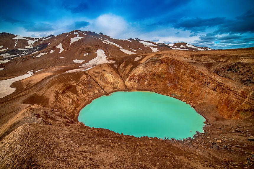
Myvatn
Myvatn, or "the lake of flies" in Icelandic, is one of the most beautiful jewels of northeastern Iceland. It's the only inhabited place in the Highlands since the 10th century Viking settlements. The lake is also one of the largest in the country and remains frozen half the year. Since 2004, the lake and the surrounding marshes have formed a protected natural reserve for the 15 species of ducks nesting here every Spring. A paradise for ornithologists! Again, there is a clear feeling of walking through a strange yet fascinating landscape, made up of mud springs, lava flows in many forms such as Dimmuborgir, vigorous fumaroles and volcanic craters which are seemingly asleep (for the time being)... From the top of the Hverfjall volcano, you can admire the splendid view over the lake and its surroundings. Its explosive crater was used as a training base by American astronauts before their trip to the Moon in 1969! The plain of Myvatn is located in the middle of the oceanic ridge, which is why its activity is so intense and its terrain so tormented. There are many paths for you to explore it. Myvatn is also the driest area on the island due to its protected geographical location north of the huge Vatnajökull ice cap.
Natural wonders | Volcano | Lake | Hiking | Animals
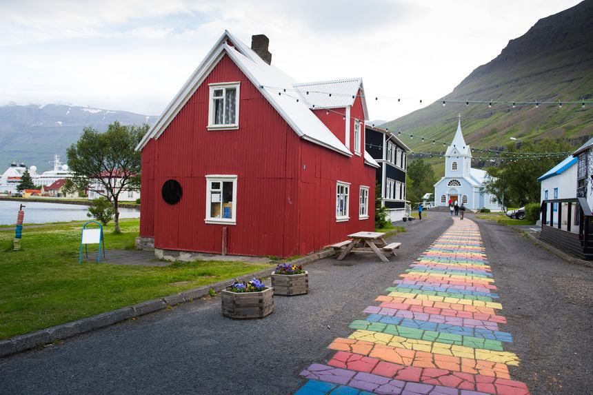
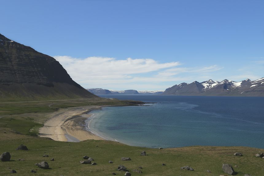
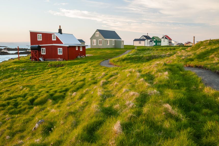
Seydisfjördur
When leaving the small town of Egilsstadir in the eastern fjords, road 93 crosses a mesmerizing landscape of austere highlands before plunging into the village of Seydisfjördur, nestled in a deep 10 miles long inlet in a breathtaking setting. If you only have to visit one village in this part of Iceland, it is undoubtedly this one! The multicoloured wooden houses, so typical of Scandinavian architecture, are surrounded by the Strandardintur and Bjolfur mountains and beautiful waterfalls, a delightful postcard setting! Founded in the middle of the 19th century by Norwegian fishermen, this village of 750 inhabitants was a base for British and American forces during the Second World War and has the particularity of being Iceland's gateway by ship: this is where the only ferry that sails once a week from Denmark arrives. But Seydisfjördur is also a village with a charming community of bohemian craftsmen and musicians. During the summer season, A Seydi, the local cultural festival, hosts many exhibitions, workshops and music concerts… An ideal stopover that combines nature and culture in this beautiful region of the Eastern Fjords.
Nice village | Craftsmanship | Lake | Art & Culture | Nature
Selardalur
Selardalur and Djupavik are equally beautiful places and worthy representatives of the country's uniqueness and enchantment. Located at the tip of Arnarfjordur Fjord in a wild area, it is accessible by following a small and well-maintained trail which goes to the village of Bildudalur. Selardalur is not a traditional village but more like a church and a few buildings that seem to have emerged from the imagination of the Icelandic artist Samuel Jonsson. In 1958, at the age of 72, he retired from being a farmer and decided to make his dreams come true by becoming an artist, devoting himself fully to his work during the last years of his life until his death in 1969. He would tirelessly extract sand and bring it back to his farm in Brautarholt to transform it into naively inspired sculptures. You can contemplate stylised figures and animals, such as a replica of the Icelandic explorer Leif Erikson and the famous Alhambra lions, in a sumptuous and very photogenic scenery. An undeniable sense of melancholic beauty emerges from this place... The artist's house was rebuilt in 2008 after some rehabilitation work, it is now an artistic and university residence.
Art & Culture | Unusual place | History | Sea | Nature
Askja caldera
Getting to Askja is a journey in itself: whether you are in your own off-road vehicle or on an organized excursion, you can access it by taking a rather rugged trail from Myvatn up north and by crossing a few deep ditches and black sands that can turn out to be treacherous... However, you will have a better chance of seeing reindeer, particularly those that are mainly concentrated in this part of the island. There is no more vegetation or trees but rather a lunar landscape. No wonder the first NASA candidates to walk on the moon came here for their training! Located between the Myvatn highlands and northern Vatnajökull, Askja is, in fact, a succession of three intertwined calderas, in the centre of the immense Odadahraun lava desert. The highlight of the site is Öskjuvatn, a beautiful deep blue lake nestled at the bottom of the caldera. It was created following the collapse of a volcano and is Iceland's deepest lake with 217 metres deep. The Viti cratercontains a second and smaller lake, with milky-green waters. The contrast is absolutely stunning when walking on the crater edge between the two lakes!
Natural wonders | Volcano | Mountain | Animals | Viewpoint
Flatey island
Flatey, which means "the flat island" in Icelandic, is located between the Snaefellsnes peninsula and the western fjords. Lost in the middle of a multitude of islets, it is only 1.2 miles long and a few dozen miles wide. You literally feel like you're being taken decades back when the Baldur ferry crossing Breidarfjördur Bay arrives for a brief moment: an apparently unaltered setting of a handful of neatly maintained colourful houses, nestled on this islet directly vulnerable to the potential raging ocean. Flatey is inhabited by some twenty residents in the summer and with only two farms remaining in activity all year round. There is a road on the island but it’s forbidden to cars due to lack of space. A good reason to swap your car for a pair of hiking shoes and to stroll between the houses and the church. The latter was restored in 1990 by Baltasar, an Icelandic-Spanish artist, and decorated with beautiful murals evoking life in the old days. An interesting cultural anecdote, the first ever library in Iceland was opened in Flatey in 1864! Another appeal to this destination is the ornithological diversity on the island, attracting many photographers from all over the world. 37 species of birds live here, among which is the magnificent Black guillemot.
Nice village | Island | Art & Culture | Animals | History
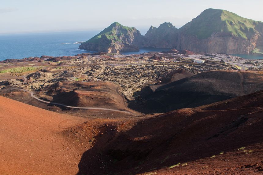
The Vestmann Islands
When your plane is approaching the Icelandic coastline, and if the weather is clear, it’s often the shredded silhouette of the Vestmann Islands that catches your eye first. The archipelago is located south of the mainland of Iceland, composed of 15 islands, with only one of them being inhabited (Heimaey). With about 4,000 residents, the island benefits from a picturesque setting with many steep cliffs on the west and two volcanic mounts, among which is the infamous Eldfell. The latter erupted continuously from January to June 1973: the lava flows enlarged the island of more than 2km² and threatened to block the entrance of the bay, which is the only natural harbour on the island, destroying 400 houses in the process! Here is where you grasp this feeling of an island in a continuous process of creation. It’s also in the area that one of the youngest islands in the world is to be found: Surtsey, born following a submarine volcanic eruption in 1963 that lasted for 4 years! Now listed as a UNESCO World Heritage site, it’s access is restricted to scientists. The main attraction of the island is the observation of birds, especially near the southern cliffs of the island: thirty species of birds are nestled in the cliffs, with the largest Puffin colony in the world with more than 10 million specimens!
UNESCO World Heritage | Island | Sea | Nature | Hiking
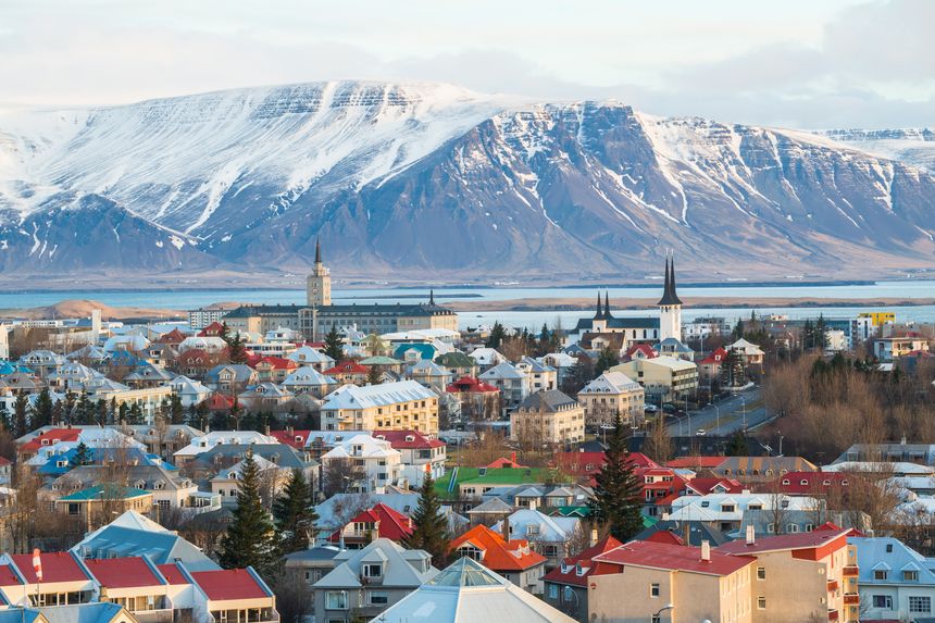
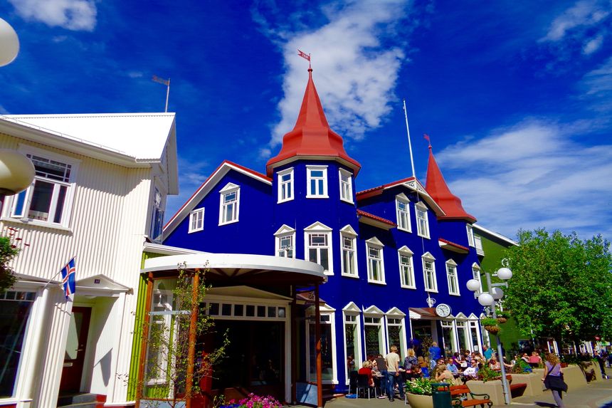
Reykjavik
Northernmost capital in the world, Reykjavik is inhabited by roughly 120,000 people, almost half of the total population of Iceland. Meaning “Bay of Smoke” in Icelandic, it is ideally situated on a peninsula bordered by two fjords facing the ocean, in an area full of hot springs, among which is the very pleasant Nautholsvik geothermal beach. There is an incredible blend of old and modern buildings, many museums and nice cafés to linger in, as well as an intense cultural and musical life that is quite surprising for a city this size. But that is only a mere reflection of the great creative sense of the Icelandic people! The Kjarvalsstadir and Ljosmyndasafn museums are worth a visit and are respectively devoted to contemporary painting, including that of the famous Icelandic painter Kjarval, and to photography in all its many forms. The city is full of architectural curiosities, such as the imposing Hallgrimskirkja church built in the last century on the top of a hill overlooking the city, its shape inspired by the basalt organs of the Icelandic volcanic landscape. Do not miss the famous "runtur" a night out discovery the pubs in the city, it's also the perfect place for music festival lovers and events of all sorts with many of them taking place all year round, including the Icelandic Pride March and the Reykjavik International Film Festival.
Art & Culture | Parks & gardens | Museums | Entertainment | Shopping
Akureyri
Nestled at the end of the long Eyjafjördur fjord and populated by about seventeen thousand inhabitants, Akureyri is the second largest city in the country. A relatively important seaport, one has the feeling of being in a mini Reykjavik when walking through its streets full of charming cafés and shops. The city centre is relatively dense and easily accessible: almost everything is concentrated around Hafnarstraeti pedestrian street, the oldest part of the city near Adalstraeti is also worth a visit. As for the Akureyri Botanical Garden, it is ideal for a short time walking on a sunny summer day: its perfectly tended lawns are home to an impressive collection of endemic plants and high-altitude plant species from different parts of the world. Of course, you will need to travel dozens of miles in the wild to reach Akureyri but the charming “capital of the North” is well worth the isolation... Snow-capped mountains surround the city, which is only 30 miles from the south of the Arctic Circle. Akureyri is also a base camp for exploring the Northern parts of Iceland, as for instance the geothermal area of Myvatn, the whale-watching excursions from the fishing harbour of Husavik or the charming village of Siglufjördur, one of the northernmost populated area of the island.
History | Parks & gardens | Port | Sports | Shopping
Mountain/environmental expert and travel journalist
Vanessa's review
I recall Iceland as a very distant country, almost lunar, located on the edge of our planet. As a snow and water sports enthusiast since I was a child, it was during a documentary on these men and women who make up the Icelandic sliding scene that I had the first opportunity to go there 10 years ago. Imagine my surprise! The unique experience of snowboarding under the midnight sun with the icy Arctic ocean in the background. It was not only these fantastic sceneries that made such an impression on me but also the people who lived on this island, lost in the middle of the North Atlantic Ocean. Many of them show a fascinating combination of apparent calm and boldness... This was the beginning of many other adventures in the country, not so much oriented towards skiing and surfing but also towards the country's stunning natural sites and to the creative and unusual cultural aspect of the country. Among all the countries I visited in my life, Iceland was undoubtedly one of my most memorable experiences the nature and wide open space lover that I am: such marvels as the Jökulsarlon, the Landmannalaugar or the Askja caldera will satisfy the most experienced travellers... As for cuisine enthusiasts, museums and festivals lovers of all kinds, you will be delighted by Icelanders' creativity since there are many events taking place all year round in all four corners of the island. Apart from the capricious Icelandic weather, travelling around the country on your own with your own rental car is a very easy thing to do: most Icelanders speak fluent English and will be delighted to help you to provide you with information in order to make your experience as pleasant as possible. Be aware though: this is a highly addictive destination!